Watch this video for a preview of the route!
Every year my family usually takes a vacation over the Christmas and New Year holidays. Being that 2020 was the year of COVID and social distancing, most of the activities we did this year were outside. Exploring in the Jeep, hiking, fishing, and just enjoying the outdoors in general. My daughter just turned 2 in December, so she is big enough for a front-facing car seat which makes for a much more comfortable Jeep trip experience for her.
While I was looking for vacation ideas for this year, I came across a blog post from Wander North Georgia titled Road Trip Rambles: A River, A Bald, And a Beer In Western Carolina. The post details a trip that starts in the North Georgia town of Clayton, GA, and travels to Franklin, NC along the Little Tennessee River, the Nantahala Outdoor Center in Bryson City, NC, and back to Franklin, NC to the summit of Wayah Bald. There is a lookout tower atop the 5,342-foot summit of the mountain.
Side note on the Wander North Georgia store: It is a wonderful store in downtown Clayton, GA that carries outdoor and hiking gear, curated products, and has one of the best book selections I have found in the state. The owners are local to Clayton Rabun County, and they also give back to the local community through their 1 percent for Rabun County initiative. I attended high school at the Rabun Gap Nachoochee School which is in Rabun Gap, GA just north of Clayton. This school had a huge impact on my trajectory in life, and Rabun County and its people are near and dear to me. Seeing this store succeed and thrive in Clayton is very satisfying. If you are ever in the area, make sure you stop by the store and check it out.
I started looking at the map to plan out the route and as one thing let to another I was on the way to planning a Great Smoky Mountain family vacation! We love a good mountain trip, and since the drive from Atlanta to the Smoky Mountains isn’t that far I figured we could make a 3 or 4-day excursion out of the trip detailed in the Wander North Georgia post. After all, who doesn’t mind fun, family-friendly free things to do in the Smoky Mountains!
While in GA we don’t always see snow on a regular basis during the winter, the Smoky Mountains in winter do. Given the higher elevation of these mountains, there are typically seasonal closures of roads and trails due to ice and snow. It can be both picturesque and quite dangerous at the same time.
While planning the trip I searched for things like “smoky mountain jeep trails”, “jeep smoky mountain”, “smoky mountains road trip”, “driving trails near me” and “best scenic drives near me” and put the notable results together in what I named The Great Smoky Mountains Jeep Road Trip & Off Road Adventure.
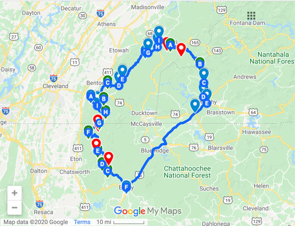
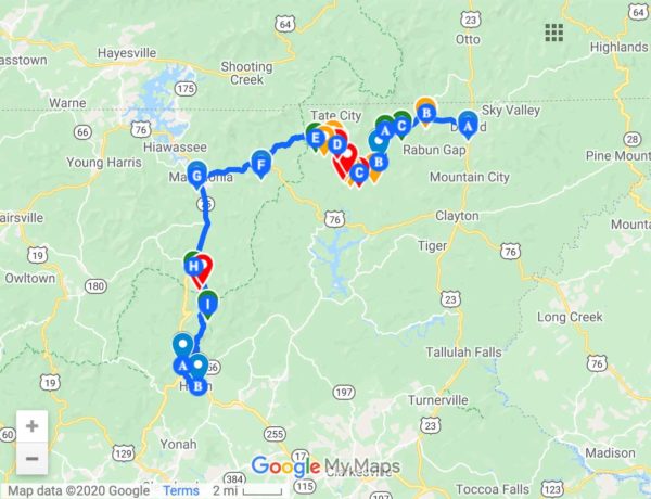
The trip starts (and returns to) at the Georgia/North Carolina state line and covers approximately 375 miles through 33 paved roads and 5 USFS Forest Service Roads. There are 30 unique points of interest or things to see or do. It travels through 11 cities and towns, the Nantahala National Forest, and the Great Smoky Mountains National Park. We covered the distance in 3 days and 4 nights.
I hope you enjoy the trip and make memories as my family did. Be sure to tag me (@Southeast4x4Trails) any photos you share on Facebook or Instagram!
NOTE: Downloadable GPS or mapping application files are available in GPX and KML formats via the links below. You can import these files into your app or GPS device of choice and follow the exact route that we took.
If you are looking for a good travel guide to the Great Smoky Mountains National Park and the surrounding areas I found Lonley Planet guide to be a great resource.
These are some of the points of interest and things to see along the route:
Julep Farms
While not directly on the route, Julep Farms is in Dillard, GA just a few minutes away from the GA/NC state line off of Hwy GA 246 which runs into Highlands, NC. We stayed in one of the four rental cottages the night before we started the trip and loved it (see the photo below). The property also features an upscale restaurant (Julep Kitchen), a market (Julep Market), coffee bar, garden, space for outdoor games and a few farm animals. The entire property is decorated in a modern farmhouse style and looks great. Click to learn more.
Nantahala Outdoor Center
Located on the Nantahala River in Bryson City, NC, the Nantahala Outdoor Center (NOC) is a center for whitewater rafting and kayaking. It is also the largest outdoor recreation company in the US. They operate guided whitewater rafting trips on a number of rivers in NC and TN. 2 restaurants, lodging, an outfitter store and other outdoor activities are located on-site.
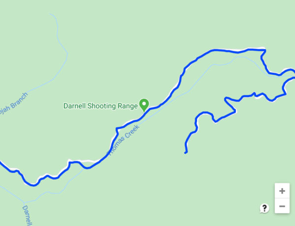
Wishon’s Fishing Hole
Also on the Nantahala River in Aquone, NC Wishon’s fishing hole is a handicap accessible concrete fishing pier that offers access to the Upper Nantahala river off of Wayah Rd. The section of the river from White Oak Creek up to the Duke Energy Power Plant (where the pier is located) is classified as delayed harvest trout waters. This means that on this section of the river, you can only fish with artificial, single hook lures and fishing is catch-and-release only from October until June. The Nantahala is also rated as a top 100 river in North America by Trout Unlimited.
Tail Of The Dragon / Hwy 129
Hwy 129 gained its nickname the “Tail of the Dragon” because it has 318 sharp curves over the course of 11 miles. It is very popular with motorcycle riders and sports car drivers, and many of them drive the road at very high speeds. There are photographers that are stationed at various curves along the road who take photos of each vehicle throughout the day (typically on the weekends or holidays). You can buy the photos online if you would like a copy of them.
If you drive the road on the weekend please drive slow, stay in your lane and watch out for oncoming cars. Multiple accidents and even fatalities occur on this road every year.
Greenback Castle / Fortress Of Faith
Located in Greenback, TN, the Greenback Castle is a brick and cinderblock castle that Floyd Banks Jr. has been building by had for the past 30 years. It is nicknamed the “Fortress Of Faith” due to the numerous spiritual messages and references on the property, but you have to visit this one in person to get the full effect and take it all in.
Look Rock Observation Tower
The hike from the Look Rock parking area to the tower is only 0.5 miles. From the top of the tower, there are 360-degree panoramic views of the surrounding mountains and the highest mountain peaks of the Great Smoky Mountain range. The elevation atop the tower is 2,696 feet. The peak of the mountain also is home to an air quality monitoring station. Visit and read the signs that are on-site to learn more about the tower and why the air quality monitoring station is located at Look Rock.
Foothills Parkway & “Missing Link” Extension
Construction of the Foothills Parkway started in 1966, but a 1.65-mile section of it between Walland and Wears Valley, TN wasn’t completed and opened to the public until November 10, 2018. That last 1.65-mile stretch is referred to as the “missing link“. Today the Foothills Parkway spans 16 miles and the sections are connected by 9 bridges. It offers excellent panoramic views and scenic overlook areas. It is open year-round, weather (snow and ice) permitting. Look Rock is located on the Foothills Parkway.
Elkmont Historic District
Located inside of the Great Smoky Mountains National Park, the Elkmont Historic District was home to a clubhouse and community of cabins from the early 20th century. Notable business leaders from the Knoxville area used it as a summer retreat. There are still some cabins dating back to this period that you can visit. Today it is home to a decent size group campground, but it was closed when we visited in December 2020 as it closes seasonally on November 1. Check the NPS Group Campgrounds status page before you visit.
Chimney Tops Mountain
Also located within the Great Smoky Mountains National Park, Chimney Tops is easily visible from US 441 / Newfound Gap Rd which is the main road that runs through the park. The peak is at 4,724 feet and it has “twin peaks” or a double-capstone knob that are bare rock. The Cherokee Indians referred to Chimney Tops as Duniskwalgunyi which means “forked antler” per its resemblance to deer antlers. Early settlers in the area referred to the knobs as a pair of stone chimneys. The 2016 wildfires that damaged much of the Smoky Mountains also swept across Chimney Tops. It is also said that the wildfires actually started at Chimney Tops. The trail to the summit is now closed due to the fires, but a new viewing platform was built about 1.75 miles into the trail and re-opened in October 2017.
Clingmans Dome
Clingmans Dome is both the highest point in Tennessee and the highest point in the Great Smoky Mountains National Park at an elevation of 6,643 feet. An iconic circular observation tower is located at the summit which can be accessed via a 0.5 mile paved trail. Clingmans Dome Rd is off of Hwy 441 / Newfound Gap Road (within the park) and runs 7 miles to the Clingmans Dome Visitor Center. The road is closed seasonally from December through March, but the observation tower is open year-round to those that want to hike in.
Mingus Mill
Minus Mill was a turbine-powered gristmill that was built in 1886. It was used to grind corn into meal and wheat into flour for the residents of the community that was established near Mingus Creek. Water was used to turn the gristmill’s stone which was fed to a water-powered cast-iron turbine. The wooden flume line is still intact at the site today. This was the largest gristmill in the Smoky Mountains for its time.
Cataloochee Valley
Located about 34 miles northeast from the park’s southern entrance in Cherokee, NC, the Cataloochee Valley settlement was the largest in the Smoky Mountains around 1910. When this area within the park is open, you can visit some of the historic buildings from the community such as the Caldwell House, Beech Grove School, Palmer Chapel and Palmer House. The hiking trails in this area are also known for their opportunities to view wildlife. Check the status to see if the area is open before you visit.
Wayah Bald & Lookout Tower
Off of Forest Service Road 69 – Wayah Bald lies the first ranger station that was built in the Nantahala National Forest – Wilson Lick which was constructed in 1913. 3 miles past the ranger station is the summit of Wayah Bald at 5,342 feet. A short paved trail runs from the summit to the Wayah Bald Fire Tower. You can see Franklin, NC, and portions of the Appalachian Mountains in Georiga, Tenessee, North and South Carolina from the tower. Forest Service Road 69 is closed seasonally from January 1st to April 1st.
US Forest Service Road Status
Please check the status of any Forest Service Roads that you plan to travel on prior to starting your trip. Visit the USFS Interactive Visitor Map and choose the search icon in the box at the top of the page and enter the name of the Forest Service Road. Click on the road name in the results and then click the map marker icon to view the details for the road.
It is also good practice to check the “Alerts & Notices” section of the USFS website for the forest that the road is in. When roads are closed they are typically updated on these pages. Click the links below to visit the page for the Nantahala National Forests. Responsible use will benefit all of us so the roads can be properly maintained and open for our enjoyment.
Forest Service Roads:
■ 422 – Winding Stairs (Open Yearlong | Gravel & Dirt | Nantahala National Forest)
■ 308 – Beachertown / Old River Rd (Open Yearlong | Gravel & Dirt | Nantahala National Forest)
■ 69 – Wayah Bald (Seasonal, Closed Jan 1st to April 1st | Gravel | Nantahala National Forest)
■ 711 – Winesprings Whiteoak (Open Yearlong | Paved | Nantahala National Forest)
MAP PIN LEGEND:
Blue – Paved Road
Green – Forest Service Road
Red – Point of Interest
Orange – Campground
Tan – City / Town
Google Maps
Click To Open In A New Window
Gaia GPS – Main Route
Click To Open In A New Window
Gaia GPS – Optional Loop
Click To Open In A New Window


4 Comments
Margarita
October 9, 2021 at 5:39 amThis is great! Thank you. We are traveling from FL to TN. You gave us many ideas
Colby
October 9, 2021 at 3:08 pmThanks for the comment, I hope you enjoy the trip!
Billy
February 21, 2022 at 12:19 pmJust purchased a brand-new-to-me Jeep and want to take some trails up in the Smokey Mountains for spring break! Not anything that gets me stranded or broken down with three kids! This gave me some great ideas! Our new ride isn’t a Pavement Princess, but we would liken it to remain a trail prince for years to come! Besides, at the end of the day it has to still get the kids to school and me back and forth to work!
Colby
February 23, 2022 at 6:50 pmThanks for the comment Billy! I’m glad that the post gave you some ideas, you are safe on any of the roads and trails in this post. I did the trip with my wife and 2-year-old daughter. I hope you and your family have a great time on spring break!